
Not just Ladakh, but other areas of India are targeted by China.

Chinese policymakers want to follow the old calculations of the "Middle Empire" (since ancient times the Chinese have called their country the "Middle Empire"). They have five specific goals: economic growth and development, confidence building, adversity management, multifaceted use of resources, and cornering Taiwan in the international arena. China also has ambitions to become a superpower.
They think that the Western world, including the United States, and their allies like India and Japan, stand in the way of fulfilling that ambition. The subject is his no-choice. Occupying Taiwan and securing its own ports, ensuring the security of the 'buffer zone' of occupied Tibet and Xinjiang, as well as neighboring countries like Mongolia, as well as controlling sea routes is a priority for China's interests, a source of its trade and strategic power. His goal is to control the mineral resources there. There is also the issue of ensuring internal security.
The source of the Corona epidemic is the city of Wuhan in China. Its devastating effects have spread around the world, and China has been criticized internationally. But China has already recovered from the epidemic. Now the country's goal is to establish its own claim through aggressive foreign policy and punish those who oppose it.
India shares a 4,000-kilometer border with Chinese-occupied Tibet to the north and east. China has illegally occupied or claimed large parts of the border. In the 1962 war, Aksai Chin occupied China near Ladakh. The area of the region is about 36 thousand square kilometers. On March 2, 1963, Pakistan ceded 5,160 square kilometers to China through an illegal agreement. Even then, China claims vast territory in eastern Ladakh.
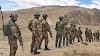
The Ladakh controversy began in 1949. After the Chinese army occupied Xinjiang and Tibet. In 1959, Aksai wrote a letter to Chinese Prime Minister Chou En-lai Jawaharlal Nehru demanding China's rights. By then they have started occupying the area. In 1962, China went further. A large part of Pangong Lake, part of the Galwan River Valley, the area around the Depsang Plain, Chumar, Hot Springs, Demchak, Daulat Beg Oldi and several other areas are claimed as their own. The Line of Actual Control (LAC) of Ladakh covers the borders of this claimed area. Its length there is about 1,596 km. China is now claiming the whole of Ladakh as theirs. Such a claim is completely unreasonable. Because, it has no real basis.
Along with Ladakh, China is provoking Nepal and creating controversy over the triangulation adjacent to the Lipulekh Pass. China is also the cause of controversy over the Bhutan-Tibet-Sikkim, Bhutan-Tibet-Arunachal and Myanmar-Tibet-Arunachal triangulation. Barahoti on the Uttarakhand-Tibetan border, the Finger Area in northern Sikkim, various regions of western, central and eastern Bhutan, including the Doklam Valley, and the whole of Arunachal Pradesh are on China's list of demands. China has never acknowledged the existence of the McMahon Line.
The exiled Tibetan government has also opposed China's position. They claim that China has never officially ruled over Tibet. In 1913, the British rulers of India started negotiating with them as an independent and sovereign state. As a result, the Shimla Agreement was signed in 2014 to demarcate the border. Both sides have accepted the McMahon Line as the demarcation line between India and Tibet.
China's counter-claim, thwarting the Indian interpretation of the McMahon line, relates only to the map of the larger context. According to them, the details of the LAC's position should be decided based on the physical presence of the two forces. A similar explanation was given in a letter to Chou En Lai written to Nehru in 1959. In 1972, the Colombo Protocol again addressed the issue of LAC. It said that the issue of reducing the dispute and reaching an agreement between the two countries was of paramount importance by identifying specific geographical boundaries. The areas of conflict on the eastern border are marked as follows:
1. Location of the triangulation on the Tibet-Sikkim-Bhutan border. Here China claims, India is further south of the demarcated border. The recent events on the Doklam Plateau and the Chinese occupation of Sarithang in western Bhutan are consistent with such claims.
2. Location of the triangle on the Tibet-Bhutan-Arunachal Pradesh border. Here, too, the Chinese claim is ‘south-facing’. China claims several territories, including Thag La Girishira, Khinjhemane, Tawang, and Bomdila, and even the Saketong area of eastern Bhutan.
3. China also claims several areas in central Bhutan. India also has some obligations here due to its defense agreement with Bhutan.
4. China also has a claim on Langju, which belongs to the Subansiri sector of Arunachal Pradesh.
5. China does not want to accept the 'fish tail' of the Dibang sector as Indian territory.
. After claiming the red sector of the Tibet-Arunachal-Myanmar tri-junction, China has also identified much of the southern Walang as its territory.
In addition, there is a possibility of a dispute between the two countries over the following areas:
Barhoti in Uttarakhand as well as some areas on the Tibet-Himachal Pradesh border. Where there is a message of Chinese rights.
In the past, after occupying Tibet, China made certain demands in the following areas:
A. Tawang area. These include Tawang and West Kameng districts of Arunachal Pradesh. The Sixth Dalai Lama was born in this region in the seventeenth century. China claims it is part of the Jongpen region of Tosna district in Tibet. However, according to the Dalai Lama and the exiled Tibetan government, the area south of the McMahon Line is "Indian territory."
B. China also claims the Potrong Ridge (another name, Crystal Mountain) in the Asafila and Subansiri and its tributary Sari Chur basins in the Subansiri Valley. Although it is an ancient pilgrimage. The nearby Longzhou and Bisa Kane bridges were illegally occupied by China in the 1980s.
C. The government of the country has also identified the Kaila Pass of the Fish Tail and the vast surrounding area as 'Chinese territory'. However, in the early stages, it was one of the reasons for the 'cartographic error' for India.
D. China also considers the Dichu Pass, the watershed of the Red Sector (the highlands that separate the course of two or more rivers) as its territory.
However, despite this long list of demands, China made a proposal in 1959, even in the late eighties, to resolve the Arunachal border dispute. The government of that country wanted to exchange those parts of Arunachal with Aksai Chin, which is under its control in the western sector. But New Delhi did not agree to that offer. After that, despite a series of meetings between the representatives of the two countries, no solution was found to resolve the border issue. However, two agreements were signed in 1993 and 2005 to maintain peace and stability on the border in the wake of talks between the two countries' top leaders. In fact, the situation improved a lot in 2003-04. At the time it seemed the border dispute could be resolved. The 2005 Manmohan Singh-Wen Jiabao meeting was a turning point in bilateral relations. There was a consensus on resolving the border dispute without relocating people.
Source: Anandabazar


0 Comments